Pages

Wednesday, June 24, 2009

Twin Tower

The World Trade Center or Twin Tower was a complex in Lower Manhattan whose seven buildings were destroyed in 2001 in the September 11 attacks. The site is currently being rebuilt with six new skyscrapers and a memorial to the casualties of the attacks. The original World Trade Center was designed by Minoru Yamasaki in the early 1960s using a tube-frame structural design for the twin 110-storey towers. In gaining approval for the project, the Port Authority of New York and New Jersey agreed to take over the Hudson & Manhattan Railroad which became the Port Authority Trans-Hudson (PATH). Groundbreaking for the World Trade Center took place on August 5, 1966. The North Tower (1) was completed in December 1970 and the South Tower (2) was finished in July 1971. Construction of the World Trade Center involved excavating a large amount of material which was used in making Battery Park City on the west side of Lower Manhattan. The complex was located in the heart of New York City's downtown financial district and contained 13.4 million square feet (1.24 million m2) of office space. The Windows on the World restaurant was located on the 106th and 107th floors of the North Tower, while the Top of the World observation deck was located on the 107th floor of the South Tower. Other World Trade Center buildings included the Marriott World Trade Center; 6 World Trade Center, which housed the United States Customs; and 7 World Trade Center, which was built in the 1980s. The World Trade Center experienced a fire on February 13, 1975 and a bombing on February 26, 1993. In 1998, the Port Authority decided to privatize the World Trade Center, leasing the buildings to a private company to manage, and awarded the lease to Silverstein Properties in July 2001. On the morning of September 11, 2001, al-Qaeda-affiliated hijackers flew two 767 jets into the complex, one into each tower, in a coordinated suicide attack. After burning for 59 minutes, the South Tower (2) collapsed, followed a half-hour later by the North Tower (1), with the attacks on the World Trade Center resulting in 2,750 deaths. 7 World Trade Center collapsed later in the day and the other buildings, though they didn't collapse, had to be demolished because they were damaged beyond repair. The process of cleanup and recovery at the World Trade Center site took eight months. The first new building at the site was 7 World Trade Center which opened in May 2006. The Lower Manhattan Development Corporation (LMDC), established in November 2001 to oversee the rebuilding process, organized competitions to select a site plan and memorial design. Memory Foundations, designed by Daniel Libeskind, was selected as the master plan, which included the 1,776-foot (541 m) 1 World Trade Center, three office towers along Church Street and a memorial designed by Michael Arad.
Twin Tower at a Glance
Location : New York City
Status : Destroyed
Constructed : 1 WTC: 1966–1972 / 2 WTC: 1966–1973
Destroyed : September 11, 2001
Antenna/Spire : WTC: 1,727 ft (526.3 m)
Roof : 1 WTC: 1,368 ft (417.0 m) / 2 WTC: 1,362 ft (415.0 m)
Top floor : 1 WTC: 1,355 ft (413.0 m) / 2 WTC: 1,348 ft (411.0 m)
Floor count : Both had 110 floors
Floor area : Both had 4,300,000 sq ft (400,000 m2)
Elevator count : Both had 99 elevators
Architect : Minoru Yamasaki & Emery Roth & Sons
Structural Engineer : Leslie E. Robertson Associates
Contractor : Tishman Realty & Construction Company
Owner : Port Authority of New York & New Jersey
(Source: http://en.wikipedia.org/wiki/World_Trade_Center)

Wednesday, June 17, 2009

Machu Picchu

Machu Picchu is a pre-Columbian Inca site located 2,430 metres (8,000 ft) above sea level. It is situated on a mountain ridge above the Urubamba Valley in Peru, which is 80 kilometres (50 mi) northwest of Cuzco and through which the Urubamba River flows. Often referred to as "The Lost City of the Incas", Machu Picchu is one of the most familiar symbols of the Inca Empire.The Incas started building it around AD 1430 but was abandoned as an official site for the Inca rulers a hundred years later at the time of the Spanish conquest of the Inca Empire. Although known locally, it was largely unknown to the outside world before being brought to international attention in 1911 by Hiram Bingham, an American historian. Since then, Machu Picchu has become an important tourist attraction. Machu Picchu was declared a Peruvian Historical Sanctuary in 1981 and a UNESCO World Heritage Site in 1983. Since it was not plundered by the Spanish when they conquered the Incas, it is especially important as a cultural site and is considered a sacred place. Machu Picchu was built in the classical Inca style, with polished dry-stone walls. Its primary buildings are the Intihuatana, the Temple of the Sun, and the Room of the Three Windows. These are located in what is known by archaeologists as the Sacred District of Machu Picchu. In September 2007, Peru and Yale University reached an agreement regarding the return of artifacts which Hiram Bingham had removed from Machu Picchu in the early twentieth century. Machu Picchu was constructed around 1462, at the height of the Inca Empire. It was abandoned less than 100 years later. It is likely that most of its inhabitants were wiped out by smallpox before the Spanish conquistadores arrived in the area, and there is no record of their having known of the remote city. Hiram Bingham hypothesized that the citadel was the traditional birthplace of the Inca of the "Virgins of the Suns". Another theory maintains that Machu Picchu was an Inca "llacta", a settlement built to control the economy of these conquered regions. Yet another asserts that it may have been built as a prison for a select few who had committed heinous crimes against Inca society. Research conducted by scholars, such as John Rowe and Richard Burger, has convinced most archaeologists that Machu Picchu was an estate of the Inca emperor, Pachacuti. In addition, Johan Reinhard presented evidence that the site was selected because of its position relative to sacred landscape features such as its mountains, which are purported to be in alignment with key astronomical events that would have been important to the Incas. Although the citadel is located only about 80 kilometers (50 miles) from Cusco, the Inca capital, it was never found by the Spanish and consequently not plundered and destroyed, as was the case with many other Inca sites. Over the centuries, the surrounding jungle grew over much of the site, and few knew of its existence. On July 24, 1911, Machu Picchu was brought to the attention of scholars by Hiram Bingham, an American historian employed as a lecturer at Yale University. Bingham was led up to Machu Picchu by a local 11 year old Quechua boy named Pablito Alvarez. Bingham undertook archaeological studies and completed a survey of the area. Bingham coined the name "The Lost City of the Incas", which was the title of his first book. (Source: http://en.wikipedia.org/wiki/Machu_Picchu)

Monday, June 15, 2009

Petra

Petra is an archaeological site in the Arabah, Ma'an Governorate, Jordan, lying on the slope of Mount Hor in a basin among the mountains which form the eastern flank of Arabah (Wadi Araba), the large valley running from the Dead Sea to the Gulf of Aqaba. It is renowned for its rock-cut architecture. Petra is also one of the new wonders of the world. The Nabateans constructed it as their capital city around 100 BC. The site remained unknown to the Western world until 1812, when it was introduced to the West by Swiss explorer Johann Ludwig Burckhardt. It was famously described as "a rose-red city half as old as time" in a Newdigate prize-winning sonnet by John William Burgon. UNESCO has described it as "one of the most precious cultural properties of man's cultural heritage." In 1985, Petra was designated a World Heritage Site. The History of Petra begins with the Kites and cairns of gazelle hunters going back into the aceramic neolithic. Evidence suggests that settlements had begun in and around there in the Eighteenth Dynasty of Egypt. It is listed in Egyptian campaign accounts and the Amarna letters as Pel, Sela or Seir). Though the city was founded relatively late, a sanctuary existed there since very ancient times. Stations 19 through 26 of the stations list of Exodus are places associated with Petra. This part of the country was biblically assigned to the Horites, the predecessors of the Edomites. The habits of the original natives may have influenced the Nabataean custom of burying the dead and offering worship in half-excavated caves. Although Petra is usually identified with Sela which also means a rock, the Biblical references refer to it as "the cleft in the rock", referring to its entrance. 2 Kings xiv. 7 seems to be more specific. In the parallel passage, however, Sela is understood to mean simply "the rock" (2 Chr. xxv. 12, see LXX). On the authority of Josephus (Antiquities of the Jews iv. 7, 1~ 4, 7), Eusebius and Jerome (Onom. sacr. 286, 71. 145, 9; 228, 55. 287, 94), assert that Rekem was the native name and Rekem appears in the Dead Sea scrolls as a prominent Edom site most closely describing Petra. But in the Aramaic versions Rekem is the name of Kadesh, implying that Josephus may have confused the two places. Sometimes the Aramaic versions give the form Rekem-Geya which recalls the name of the village El-ji, southeast of Petra. The capital, however, would hardly be defined by the name of a neighboring village. The Semitic name of the city, if not Sela, remains unknown. The passage in Diodorus Siculus (xix. 94–97) which describes the expeditions which Antigonus sent against the Nabataeans in 312 BC is understood to throw some light upon the history of Petra, but the "petra" referred to as a natural fortress and place of refuge cannot be a proper name and the description implies that the town was not yet in existence. (Source: http://en.wikipedia.org/wiki/Petra)

Sunday, June 14, 2009

Christ the Redeemer

Christ the Redeemer is a statue of Jesus Christ in Rio de Janeiro, Brazil. The statue stands 30 metres (98 ft) wide and 38 metres (120 ft) tall with its pedestal. It weighs 635 tons (700 short tons), and is located at the peak of the 700 metres (2,300 ft) Corcovado mountain in the Tijuca Forest National Park overlooking the city. It is one of the tallest of its kind in the world. The statue of Cristo de la Concordia in Cochabamba, Bolivia, is slightly taller, standing at 34.20 metres (112.2 ft) tall and 40.44 metres (132.7 ft) tall with its 6.24 metres (20.5 ft) pedestal. A symbol of Christianity, the statue has become an icon of Rio and Brazil. The statue of Christ the Redeemer is a very important symbol of Brazil's Christianity. It is made of reinforced concrete and soapstone.
The idea for erecting a large statue atop Corcovado was first suggested in the mid 1850s, when Catholic priest Pedro Maria Boss requested financing from Princess Isabel to build a large religious monument. Princess Isabel did not think much of the idea and it was completely dismissed in 1889, when Brazil became a Republic, with laws mandating the separation of church and state. The second proposal for a large landmark statue on the mountain was made in 1921 by the Catholic Circle of Rio. The group organised an event called Semana do Monumento ("Monument Week") to attract donations and collect signatures to support the building of the statue. The donations came mostly from Brazilian Catholics. The designs considered for the "Statue of the Christ" included a representation of the Christian cross, a statue of Jesus with a globe in his hands, and a pedestal symbolizing the world. The statue of Christ the Redeemer with open arms was chosen. Local engineer Heitor da Silva Costa designed the statue; it was sculpted by French sculptor Paul Landowski. A group of engineers and technicians studied Landowski's submissions and the decision was made to build the structure out of reinforced concrete (designed by Albert Caquot) instead of steel, more suitable for the cross-shaped statue. The outer layers are soapstone, chosen for its enduring qualities and ease of use. Construction took nine years, from 1922 to 1931. The monument was opened on October 12, 1931. The cost of the monument was $250,000. The statue was meant to be lit by a battery of floodlights triggered remotely by shortwave radio pioneer Guglielmo Marconi, stationed 5,700 miles (9,200 km) away in Rome, but poor weather affected the signal and it had to be lit by workers in Rio.

Chichen Itza

Chichen Itza is a large pre-Columbian archaeological site built by the Maya civilization located in the northern center of the Yucatán Peninsula, in the Yucatán state, present-day Mexico. Chichen Itza was a major regional focal point in the northern Maya lowlands from the Late Classic through the Terminal Classic and into the early portion of the Early Post classic period. The site exhibits a multitude of architectural styles, from what is called “Mexican zed” and reminiscent of styles seen in central Mexico to the Puuc style found among the Puuc Maya of the northern lowlands. The presence of central Mexican styles was once thought to have been representative of direct migration or even conquest from central Mexico, but most contemporary interpretations view the presence of these non-Maya styles more as the result of cultural diffusion. The ruins of Chichen Itza are federal property, and the site’s stewardship is maintained by Mexico’s Instituto Nacional de Antropología e Historia (National Institute of Anthropology and History, INAH). The land under the monuments, however, is privately-owned by the Barbachano family. Northern Yucatán is arid, and the interior has no above-ground rivers. There are two large, natural sink holes, called cenotes, that could have provided plentiful water year round at Chichen, making it attractive for settlement. Of the two centos, the "Cenote Sagrado" or Sacred Cenote (also variously known as the Sacred Well or Well of Sacrifice), is the more famous. According to post-Conquest sources (Maya and Spanish), pre-Columbian Maya sacrificed objects and human beings into the cenote as a form of worship to the Maya rain god Chaac. Edward Herbert Thompson dredged the Cenote Sagrado from 1904 to 1910, and recovered artifacts of gold, jade, pottery, and incense, as well as human remains. A recent study of human remains taken from the Cenote Sagrado found that they had wounds consistent with human sacrifice. (Source: http://en.wikipedia.org/wiki/Chichen_Itza)

Abu Simbel

Abu Simbel is an archaeological site comprising two massive rock temples in southern Egypt on the western bank of Lake Nasser about 290 km southwest of Aswan. It is part of the UNESCO World Heritage Site known as the "Nubian Monuments", which run from Abu Simbel downriver to Philae (near Aswan). The twin temples were originally carved out of the mountainside during the reign of Pharaoh Ramesses II in the 13th century BC, as a lasting monument to himself and his queen Nefertari, to commemorate his alleged victory at the Battle of Kadesh, and to intimidate his Nubian neighbors. However, the complex was relocated in its entirety in the 1960s, on an artificial hill made from a domed structure, high above the Aswan High Dam reservoir. The relocation of the temples was necessary to avoid their being submerged during the creation of Lake Nasser, the massive artificial water reservoir formed after the building of the Aswan High Dam on the Nile River. Abu Simbel remains one of Egypt's top tourist attractions. Construction of the temple complex started in approximately 1244 BC and lasted for about 20 years, until 1224 BC. Known as the "Temple of Ramesses, beloved by Amun", it was one of six rock temples erected in Nubia during the long reign of Ramesses II. Their purpose was to impress Egypt's southern neighbors, and also to reinforce the status of Egyptian religion in the region. Historians say that the design of Abu Simbel expresses a bit of ego and pride in Ramses II. With the passage of time, the temples fell into disuse and eventually became covered by sand. Already in the 6th century BC, the sand covered the statues of the main temple up to their knees. The temple was forgotten until 1813, when Swiss orientalist JL Burckhardt found the top frieze of the main temple. Burckhardt talked about his discovery with Italian explorer Giovanni Belzoni, who travelled to the site, but was unable to dig out an entry to the temple. Belzoni returned in 1817, this time succeeding in his attempt to enter the complex. He took everything valuable and portable with him. Tour guides at the site relate the legend that "Abu Simbel" was a young local boy who guided these early re-discoverers to the site of the buried temple which he had seen from time to time in the shifting sands. Eventually, they named the complex after him: Abu Simbel. (Source: http://en.wikipedia.org/wiki/Abu_simbel)

Saturday, June 13, 2009

Hawa Mahal

Hawa Mahal is a palace in Jaipur, India. It was built in 1799 by Maharaja Sawai Pratap Singh, and designed by Lal Chand Usta in the form of the crown of Krishna, the Hindu god. It forms part of the City Palace and extends the Zenana or women's chambers, the chambers of the harem. Its original intention was to allow royal ladies to observe everyday life in the street below without being seen. It has five stories and is constructed of red and pink sandstone, highlighted with white quakeee quick lime. The side facing the street outside the palace complex has 953 small windows, and the breeze (hawa) which circulates through these windows gives the palace its name, and keeps it cool even in hot months. The entrance opens onto a courtyard with a double-storied building on three sides, and one on the eastern wing with three more stories, which is just one room wide. There are no stairs to reach the upper floors, only ramps. (Source: http://en.wikipedia.org/wiki/Hawa_Mahal)

Delhi Fort

The Delhi Fort also known as Lal Qil'ah, or Lal Qila is located in the walled city of Delhi, India and became a UNESCO World Heritage Site in 2007. The Red fort was initially built by Raja Anangpal, a Rajput Tomar king. It was further expanded and improved upon its inclusion into the city of Shahjahanabad constructed by the Emperor Shah Jahan in 1639 A.D. The Red Fort was originally referred to as "Qila-i-Mubarak" (the blessed fort), because it was the residence of the royal family. The layout of the Red Fort was organised to retain and integrate this site with the Salimgarh Fort. The fortress palace is an important focal point of the medieval city of Shahjahanabad. The planning and aesthetics of the Red Fort represent the zenith of Mughal creativity which prevailed during the reign of Emperor Shah Jahan. This Fort has had many developments added on after its construction by Emperor Shahjahan. The significant phases of development were under Aurangzeb and later Mughal rulers. Important physical changes were carried out in the overall settings of the site after the First War of Independence during British Rule in 1857. After Independence, the site experienced a few changes in terms of addition/alteration to the structures. During the British period the Fort was mainly used as a cantonment and even after Independence, a significant part of the Fort remained under the control of the Indian Army until the year 2003. The Red Fort was the palace for Mughal Emperor Shah Jahan's new capital, Shahjahanabad, the seventh great city in the Delhi site. He moved his capital from Agra in a move designed to bring prestige to his reign, and to provide ample opportunity to apply his ambitious building schemes and interests. The fort lies along the Yamuna River, which fed the moats that surround most of the wall. The wall at its north-eastern corner is adjacent to an older fort, the Salimgarh Fort, a defense built by Islam Shah Suri in 1546.The construction of the Red Fort began in 1638 and was completed by 1648. On 11 March 1783, Sikhs briefly entered Red Fort in Delhi and occupied the Diwan-i-Am. The city was essentially surrendered by the Mughal wazir in cahoots with his Sikh Allies. This task was carried out under the command of the Sardar Baghel Singh Dhaliwal of the Karor Singhia misl. The last Mughal emperor to occupy the fort was Bahadur Shah II "Zafar". Despite being the`seat of Mughal power and its defensive capabilities, the Red Fort was not defended during the 1857 uprising against the British. After the failure of the 1857 rebellion, Zafar left the fort on 17 September. He returned to Red Fort as a prisoner of the British. Zafar was tried on in a trial starting on 27 January 1858, and was exiled on 7 October. On 15 August 1947, India became an independent nation. This was marked by Jawahar Lal Nehru, the Prime Minister of India, unveiling the flag of independent India on 15 August 1947. This practice of unfurling the national flag with a speech by the Prime Minister on Independence Day continues to this day. Just after World War II, the Red Fort had been the scene of the famous trial of the Indian National Army. (Source: http://en.wikipedia.org/wiki/Red_Fort)

Amber Fort

Amber Fort is located in Amber, 11 km from Jaipur, Rajasthan state, India. It was the ancient citadel of the ruling Kachhawa clan of Amber, before the capital was shifted to present day Jaipur. Amber Fort is known for its unique artistic style, blending both Hindu and Muslim (Mughal) elements, and its ornate and breathtaking artistic mastery. The fort borders the Maota Lake, and is a major tourist attraction in Rajasthan. Amber was originally built by the Meenas in the town they consecrated to Amba, the Mother Goddess, whom they knew as `Gatta Rani' or `Queen of the Pass' [ Tod.II.282 ]. Built over the remnants of an earlier structure, the palace complex which stands today was commenced under the reign of Raja Man Singh, Commander in Chief of Akbar’s army and a member of the Emperor's inner circle of nine courtiers, in 1592. The initial structure of the fort was entirely completed by his descendant, Jai Singh I. Amber was modified by successive rulers over the next 150 years, until the Kachwahas shifted their capital to Jaipur during the time of Sawai Jai Singh II. The structure which is known today as "Amber Fort" was initially a palace complex within the original fort of Amber that is today known as Jaigarh Fort. Connected to Amber via fortified passages, Jaigarh Fort is located on a hill above the Amber complex, and is constructed of red sandstone and white marble. It overlooks Maotha Lake, and was reputed to be the treasure vault of the Kacchwaha rulers. (Source: http://en.wikipedia.org/wiki/Amber_Fort)

Durbar Square

Durbar Square is the plaza opposite the old royal palace in the three main cities in the Kathmandu Valley in Nepal: Kathmandu, Patan and Bhaktapur. The square is filled with temples. The Durbar square is surrounded by spectacular architecture and vividly showcases the skills of the Newari artists and craftsmen over several centuries. The royal palace was originally situated at Dattaraya square and was only later moved to the Durbar sqaure location. Unlike the Durbar squares at Kathamandu and Patan, the one at Bhaktapur lies to the north of the city. It is linked to the more important square called Tomadhi Tol via small alleyways. The Durbar square at Bhaktapur was severely damaged by an earthquake in 1934 and hence appears more spacious than the others, located at Kathmandu and Pathan. Originally, there were 99 courtyards attached to this place, but now only 6 remain. Prior to the earthquake, there were 3 separate groups of temples. But currently, the square itself is surrounded just by buildings that survived the quake. (Source:http://en.wikipedia.org/wiki/Durbar_square)

Friday, June 12, 2009

Minar-e-Pakistan

Minar-e-Pakistan is a tall minaret in Iqbal Park Lahore, built in commemoration of the Lahore Resolution. The minaret reflects a blend of Mughal and modern architecture, and is constructed on the site where on March 23, 1940, seven years before the formation of Pakistan, the Muslim League passed the Lahore Resolution (Qarardad-e-Lahore), demanding the creation of Pakistan. This was the first official declaration to establish a separate homeland for the Muslims living in the subcontinent. Pakistan now celebrates this day as a national holiday each year. The monument attracts visitors from all over Pakistan, as well as the inhabitants of the Walled City of Lahore. The large public space around the monument is commonly used for political and public meetings, whereas Iqbal Park area is ever so popular among kite-flyers. The tower was designed by Naseer-ud-Deen Murat Khan a Pakistani architect of (Daghestan) Russian descent,and structural engineer was Abdur Rahman Khan Niazi . The foundation stone was laid on March 23, 1960. The construction took eight years of time, and was completed in 1968 at a cost of PKR 500,000. Today, the minaret provides a panoramic view to visitors who can climb up the stairs or through an Elevator. The parks around the monument include marble fountains and an artificial lake. The base is about 8 meters above the ground. The tower rises about 60 meters on the base, thus the total height of minaret is about 72 meters above the ground. The unfolding petals of the flower-like base are 9 meters high. The diameter of the tower is about 97.5 meters (320 feet). The base platform is shaped like a five-pointed star and encloses two crescent shaped pools. There is a central spiral staircase rising up with 162 steps. The top-dome of the minaret is made of Stainless steel inlaid with fine glass pieces. The structure is made of reinforced concrete, stones, and marble. The rostrum is built of patterned tiles, and faces the Badshahi Mosque. The base comprises four platforms. To symbolise humble beginnings of the freedom struggle, first platform is built with uncut Taxila stones, second platform is made of hammer-dressed stones, whereas third platform is of chiselled stones. Polished white marble at the fourth and final platform depicts the success of the Pakistan Movement. Source: (http://en.wikipedia.org/wiki/Minar-e-Pakistan)

India Gate

The India Gate is one of the largest war memorials in India. Situated in the heart of New Delhi, India Gate was designed by Sir Edwin Lutyens. Originally known as All India War Memorial, it is a prominent landmark in Delhi and commemorates the 90,000 soldiers of the erstwhile British Indian Army who lost their lives fighting for the Indian Empire in World War I and the Afghan Wars. Originally, a Statue of King George V had stood under the now-vacant canopy in front of the India Gate, and was removed to Coronation Park with other statues. Following India's independence, India Gate became the site of the Indian Army's Tomb of the Unknown Soldier, known as the Amar Jawan Jyoti (Immortal Soldier). Burning in a shrine under the arch of India Gate since 1971 is the Amar Jawan Jyoti (the flame of the immortal warrior), which marks the Tomb of the Unknown Soldier. The shrine itself is a black marble cenotaph with a rifle placed on its barrel, crested by a soldier's helmet. Each face of the cenotaph has inscribed in gold the words "Amar Jawan" (Immortal Warrior). This cenotaph is itself placed on an edifice which has on its four corners four torches that are perpetually kept alive. It was unveiled on January 26, 1972 by the then Prime Minister Indira Gandhi, in the wake of the Indo-Pakistani War of 1971. Today, it is customary for the President and the Prime Minister, as well as visiting Guests of State, to pay homage at the site on occasions of State ceremonies, and each Republic Day, 26th January, the Prime Minister pays homage to the soldiers along with Heads of Armed Forces, before joining the annual parade at the Rajpath. (Source: http://en.wikipedia.org/wiki/India_Gate)

Elephanta Caves

The Elephanta Caves are caves located on Elephanta Island in the Arabian Sea near Mumbai, India that contain Shaivistic high reliefs in stone of Hindu deities important to worshipers of Shiva. The sculptures were created beginning in the late Gupta Empire, or some time after, and at later dates. Elephanta Island was designated a UNESCO World Heritage Site in 1987 to preserve the artwork. The original name of this epitome of temple art is Agraharpuri. Agrahar is the necklace or most important neck ornament. The Agraharpuri slowly became Gharapuri; still retaining the original meaning as the focal point of Gharapuri Island, which was renamed Elephanta Island by the Portuguese and is located in Mumbai harbour off the coast of Mumbai (formerly known as Bombay), India. In 1987, the caves were designated a UNESCO World Heritage Site. The caves are thought to date back to the Silhara kings of the 9th through 13th centuries (810–1260). Some of the sculptures of this site are also attributed to the imperial Rashtrakutas of Manyakheta (in present day Karnataka), the Trimurti of Elephanta showing the three faces of Shiva almost akin to the Trinity of Brahma, Vishnu, and Mahesh. This was also the royal insignia of the Rashtrakutas. Other Rashtrakuta sculptures here are the reliefs of Nataraja and Sadashiva and the splendid sculptures of Ardhanarishvara. The rock-cut temple complex cover an area of 60,000 sq ft (5,600 m2) consisting of a main chamber, 2 lateral ones, courtyards and subsidiary shrines. The site of these magnificent caves contained beautiful reliefs, sculptures, and a temple to the Hindu god Śiva. The caves are hewn from solid rock. The temple complex is said to be the abode of Shiva.

Great Wall of China

The Great Wall of China is a series of stone and earthen fortifications in northern China, built, rebuilt, and maintained between the 5th century BC and the 16th century to protect the northern borders of the Chinese Empire from Xiongnu attacks during various successive dynasties. Since the 5th century BC, several walls have been built that were referred to as the Great Wall. One of the most famous is the wall built between 220–206 BC by the first Emperor of China, Qin Shi Huang. Little of that wall remains; it lay farther north than the current wall, which was built during the Ming Dynasty. The Great Wall stretches over approximately 6,400 km (4,000 miles) from Shanhaiguan in the east to Lop Nur in the west, along an arc that roughly delineates the southern edge of Inner Mongolia, but stretches to over 6,700 km (4,160 miles) in total; a more recent archaeological survey using advanced technologies points out that the entire Great Wall, with all of its branches, stretches for 8,851.8 km (5,500.3 mi). At its peak, the Ming Wall was guarded by more than one million men. It has been estimated that somewhere in the range of 2 to 3 million Chinese died as part of the centuries-long project of building the wall.

Uttara Gana Bhaban

The Uttara Gana Bhaban is situated 1 hour drive from Hotel Naz Garden. Natore is one of the historic towns in Bangladesh. A North Bengal Official Residence of the Hon'ble President of Bangladesh, which is 300 years oldest and enchanting archaeological Royal Palace (Rajbari). This was the residential place of historical and famous Raja of Natore Dighapatia Estate. Inside the palace there are lots to see and enjoy like Darbar Hall Jalsha Ghar, Temple, Weapons and Clothes of the Raja. In between 5 km there is another Royal Palace (Rajbari) called Palace of Rani Bhabani. It is also oldest and enchanting archaeological palace that is constructed on 60 acres of land and inside the palace there is Rani Bhabani Central Jubo Park, Picnic Spots, 6 largest Ponds, Temple etc., to observe and enjoy.

Baitul Mukarram Mosque

Baitul Mukarram Mosque is the National Mosque of Bangladesh. Its construction began on 27 January 1960, and has been going on in phases. In the late 1950s Dhaka grew very rapidly. Abdul Latif Ibrahim Bawani first came up with the idea of building a grand mosque with a large capacity. The 'Baitul Mukarram Mosque Society' was formed in 1959 to facilitate the project. Land was allocated for the mosque complex at the meeting point of Old and New Dhaka. The site was also in close proximity to the central business district of the city. Architect T Abdul Hussain Thariani was commissioned to design the mosque complex. The plan included shops, offices, libraries and parking areas within the complex. The design of the mosque reflects the architecture of the period as can be seen from the use of a white and almost cube-form for the main building. A Mosque without a dome over the roof of its main prayer hall must have been a unique experiment. The main building is eight storied and 99 feet high from the ground level. According to the original plan, the main entrance of the mosque was to be on the eastern side. The shahan on the east is 29,000 square feet with ablution space on its south and north sides. The absence of a dome on the main building is compensated by the two shallow domed entrance porticoes, one on the south, and the other on the north. The elevation of these porticoes consists of three horseshoe shaped arches, the middle of which is bigger than the rest. Two patios ensure that enough light and air enter the prayer hall. The area of the main prayer hall is 26,517 square feet with a mezzanine floor of 1,840 square feet at the eastern side. The hall is surrounded by verandas on three of its sides. The mihrab of the hall is rectangular instead of semi-circular. Excessive ornamentation is avoided throughout the mosque, since minimizing ornamentation is typical of modern architecture. According to Thariani's original plan, the minar was a detached structure on the south side of the main building. However, two new minars are now under construction according to a new plan. The Baitul Mokarram mosque is modern in its architectural style. But it has not discarded traditional principles of mosque architecture. It has found its place in the hearts of the Muslims because of the resemblance of its form to the famous Kaba at Mecca.

Friday, June 5, 2009

The Roman Coliseum

The Colosseum or Roman Coliseum, originally the Flavian Amphitheatre is an elliptical amphitheatre in the center of the city of Rome, Italy, the largest ever built in the Roman Empire. It is one of the greatest works of Roman architecture and Roman engineering. Occupying a site just east of the Roman Forum, its construction started between 70 and 72 AD under the emperor Vespasian and was completed in 80 AD under Titus, with further modifications being made during Domitian's reign (81–96). The name "Amphitheatrum Flavium" derives from both Vespasian's and Titus's family name Capable of seating 50,000 spectators, the Colosseum was used for gladiatorial contests and public spectacles. As well as the gladiatorial games, other public spectacles were held there, such as mock sea battles, animal hunts, executions, re-enactments of famous battles, and dramas based on Classical mythology. The building ceased to be used for entertainment in the early medieval era. It was later reused for such purposes as housing, workshops and quarters for a religious order, a fortress, a quarry, and a Christian shrine. It has been estimated that about 500,000 people and over a million wild animals died in the Colosseum games. Although in the 21st century it stays partially ruined due to damage caused by devastating earthquakes and stone-robbers, the Colosseum is an iconic symbol of Imperial Rome and its breakthrough achievements in earthquake engineering. It is one of Rome's most popular tourist attractions and still has close connections with the Roman Catholic Church, as each Good Friday the Pope leads a torchlight "Way of the Cross" procession around the various levels of the amphitheatre. The Colosseum is also depicted on the Italian version of the five-cent euro coin. (Source:http://en.wikipedia.org/wiki/Colosseum)

The Eiffel Tower

The Eiffel Tower is an iron tower built on the Champ de Mars beside the Seine River in Paris. The tower has become a global icon of France and is one of the most recognizable structures in the world. Named after its designer, engineer Gustavo Eiffel, the Eiffel Tower is the tallest building in Paris. More than 200,000,000 people have visited the tower since its construction in 1889, including 6,719,200 in 2006, making it the most visited paid monument in the world. Including the 24 m (79 ft) antenna, the structure is 324 m (1,063 ft) high (since 2000), which is equivalent to about 81 levels in a conventional building. At the time of completion in 1889, it was the world's tallest tower — a title it retained until 1930 when New York City's Chrysler Building (319 m — 1,047 ft tall) was completed. The tower is now the fifth-tallest structure in France and the tallest structure in Paris, with the second-tallest being the Tour Montparnasse (210 m — 689 ft), although that will soon be surpassed by Tour AXA (225.11 m — 738.36 ft). The metal structure of the Eiffel Tower weighs 7,300 tones while the entire structure including non-metal components is approximately 10,000 tones. Depending on the ambient temperature, the top of the tower may shift away from the sun by up to 18 cm (7 in) because of thermal expansion of the metal on the side facing the sun. The tower also sways 6–7 cm (2–3 in) in the wind. The structure was built between 1887 and 1889 as the entrance arch for the Exposition Universally, a World's Fair marking the centennial celebration of the French Revolution. Eiffel originally planned to build the tower in Barcelona, for the Universal Exposition of 1888, but those responsible at the Barcelona city hall thought it was a strange and expensive construction, which did not fit into the design of the city. After the refusal of the Consistory of Barcelona, Eiffel submitted his draft to those responsible for the Universal Exhibition in Paris, where he would build his tower a year later, in 1889. The tower was inaugurated on 31 March 1889, and opened on 6 May. Three hundred workers joined together 18,038 pieces of puddle iron (a very pure form of structural iron), using two and a half million rivets, in a structural design by Maurice Koechlin. The risk of accident was great, for unlike modern skyscrapers the tower is an open frame without any intermediate floors except the two platforms. However, because Eiffel took safety precautions, including the use of movable staging, guard-rails and screens, only one man died. (Source:http://en.wikipedia.org/wiki/Eiffel_Tower)

Sunday, May 31, 2009

Kangchenjunga Hill

Kangchenjunga is the third highest mountain in the world (after Mount Everest and K2), with an elevation of 8,586 meters (28,169 ft). Kangchenjunga translated means "The Five Treasures of Snows", as it contains five peaks, four of them over 8,450 meters, the treasures representing the five repositories of God, which are gold, silver, gems, grain, and holy books. Kangchenjunga is also called SewaLungma in the local Limbu language and is considered sacred in the Kirant religion. Three of the five peaks (main, central, and south) are on the border of North Sikkim district of Sikkim, India and Taplejung District of Nepal, while the other two are completely in Taplejung District. Nepal is home to the Kangchenjunga Conservation Area Project run by the World Wildlife Fund, in association with HMG in Nepal, the sanctuary is also home to the Red Panda and other snow animals, birds and plants. India's side of Kangchenjunga also has a protected park area called the Khangchendzonga National Park. Although Kangchenjunga is the official spelling adopted by Douglas Freshfield, A.M. Kellas, and the Royal Geographical Society that gives the best indication of the Tibetan pronunciation, there are a number of alternative spellings which include Kangchen Dzö-nga, Khangchendzonga, Kanchenjanga, Kachendzonga, Kanchenjunga or Kangchanfanga. The final word on the use of the name Kangchenjunga came from His Highness Sir Tashi Namgyal, the Maharaja or chogyal of Sikkim, who stated that "although junga had no meaning in Tibetan, it really ought to have been Zod-nga (treasure, five) Kang-chen (snow, big) to convey the meaning correctly". Following consultations with a Lieutenant-Colonel J.L.R. Weir (HMG political agent to Sikkim), he agreed that it was best to leave it as Kangchenjunga, and thus the name remained so by acceptance and usage. Until 1852, Kangchenjunga was assumed to be the highest mountain in the world, but calculations made by the British Great Trigonometric Survey in 1849 came to the conclusion that Mount Everest (known as Peak XV at the time) was the highest and Kangchenjunga the third-highest. Kangchenjunga was first climbed on May 25, 1955 by Joe Brown and George Band of a British expedition. The British expedition honored the beliefs of the Sikkimese, who hold the summit sacred, by stopping a few feet short of the actual summit. Most successful summit parties since then have followed this tradition. (Source: http://en.wikipedia.org)

Saturday, May 30, 2009

Big Ben

Big Ben is the nickname for the great bell of the clock at the north-eastern end of the Palace of Westminster in London. The nickname is often also used to refer to the clock and the clock tower. This is the world's largest four-faced, chiming clock and the third largest free-standing clock tower in the world. It celebrates its 150th birthday in 2009, during which celebratory events are planned. The nearest London Underground station is Westminster on the Circle, District and Jubilee lines. The clock faces are large enough to have once allowed the Clock Tower to be the largest four-faced clock in the world, but have since been outdone by the Allen-Bradley Clock Tower in Milwaukee, Wisconsin. However, the builders of the Allen-Bradley Clock Tower did not add chimes to the clock, so the Great Clock of Westminster still holds the title of the "world's largest four-faced chiming clock". The face of the Great Clock of Westminster. The hour hand is 2.7 metres (9 ft) long and the minute hand is 4.3 metres (14 ft) long. The clock and dials were designed by Augustus Pugin. The clock faces are set in an iron frame 7 metres (23 ft) in diameter, supporting 312 pieces of opal glass, rather like a stained-glass window. Some of the glass pieces may be removed for inspection of the hands. The surround of the dials is gilded. At the base of each clock face in gilt letters is the Latin inscription DOMINE. (Source: http://en.wikipedia.org/)

National Parliament of Bangladesh

Jatiyo Sangshad or National Assembly is the national parliament of Bangladesh. It is one of the most majestic public buildings in Bangladesh. The National Parliament (Sangsad Bhaban) complex is located at Sher-e-Bangla Nagar of Dhaka city. The current parliament of Bangladesh contains 345 seats including 45 women reserved seats distributed on elected party position in the parliament, the occupants of which are called Members of Parliament or MPs.The National Parliament Building is an architectural masterpiece for which the nation can be said to be justifiably proud. The decision to construct the National Parliament Complex at Dhaka was originally taken in 1959. Louis I Kahn. One of the greatest architects of the time was initially selected for designing the complex. Which would include the National Parliament Building. Hostels for members of parliament. Ministers and secretaries. Hospitality halls and communally buildings. All linked by roads and walkways and surrounded by attractive gardens and lakes. The main characteristic of the building is its monumentally. The mass of concrete lined with marble strips, the outer wall punctuate by pure geometrical openings and the dominating circular and rectangular concrete masses impart a supreme monumentality to the building quite suited to its noble function. The main building complex consists of nine individual blocks, of which eight at its periphery rise to a height of 35 meters, while the octagonal block at the centre shoots up to 52 meters. The central block accommodates the Parliament chamber with a capacity of 354 seats for members of the parliament. The entire complex has a floor area or 76,487 SQ meters in the main building, 20725 sq meters in the South Plaza and 6,041 sq meters in the North Plaza. There is not a single column in the entire building. Hollow columns that are parts of space enclosures have been adapted as structural supports. One of the important considerations in designing the building was protection from the sun and rain. The structure provides a visual impression or a majestic edifice. It avoided the conventional method of placing windows in the exterior and the disadvantages of monumental composition were removed by the provision of core walls with small gaps in between. Architecturally, the complex marks a distinct departure from the rest of the modern buildings in Dhaka.

Shwedagon Pagoda

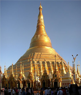
The Shwedagon Pagoda also known as the Golden Pagoda, is a 98-metre (approx. 321.5 feet) gilded stupa located in Yangon, Burma. The pagoda lies to the west of Kandawgyi Lake, on Singuttara Hill, thus dominating the skyline of the city. It is the most sacred Buddhist pagoda for the Burmese with relics of the past four Buddhas enshrined within, namely the staff of Kakusandha, the water filter of Konagamana, a piece of the robe of Kassapa and eight hairs of Gautama, the historical Buddha. According to legend, the Shwedagon Pagoda is 2500 years old. Archaeologists believe the stupa was actually built sometime between the 6th and 10th centuries by the Mon, but this is a very controversial issue because according to the records by Buddhist monks it was built before Lord Buddha died in 486 BC. The story of Shwedagon Pagoda begins with two merchant brothers, Taphussa and Bhallika, from the land of Ramanya, meeting the Lord Gautama Buddha and receiving eight of the Buddha's hairs to be enshrined in Burma. The two brothers made their way to Burma and with the help of the local king, King Okkalapa, found Singuttara Hill, where relics of other Buddhas preceding Gautama Buddha had been enshrined. When the hairs were taken from their golden casket to be enshrined some incredible things happened:
There was a tumult among men and spirits ... rays emitted by the Hairs penetrated up to the heavens above and down to hell ... the blind beheld objects ... the deaf heard sounds ... the dumb spoke distinctly ... the earth quaked ... the winds of the ocean blew ... Mount Meru shook ... lightning flashed ... gems rained down until they were knee deep ... all trees of the Himalayas, though not in season, bore blossoms and fruit
The stupa fell into disrepair until the 1300s when the Mon king Binnya U of Bago had the stupa rebuilt to a height of 18 meters (60 ft). It was rebuilt several times and reached its current height of 98 meters (320 ft) in the 15th century. The Mon kingdom possessed two great pagodas of especial sanctity, the Shwemawdaw at Bago and the Shwedagon. Originally only twenty-seven feet high, it was raised to a height of sixty-six feet in 1362 by King Binnya U as an act of special piety. Dhammazedi's immediate predecessor, his mother-in-law Queen Shinsawbu (1453-72), raised its height to 40 meters (129 ft). She terraced the hill on which it stands, paved the top terrace with flagstones, and assigned land and hereditary slaves for its maintenance. When in 1472 she yielded up the throne to Dhammazedi, she retired to Dagon, and during her last illness had her bed placed so that she could rest her dying eyes upon the gilded dome of the sacred fane. The Mon face of the Shwe Dagon inscription catalogues a list of repairs beginning in 1436 and finishing during Dhammazedi's reign. It mentions Queen Shinsawbu under a terrific Pali name of sixty-six letters. By the beginning of the sixteenth century the pagoda had become the most famous place of pilgrimage in Burma. A series of earthquakes during the next centuries caused damage. The worst damage came from a 1768 earthquake that brought down the top of the stupa and it was raised to its current state by King Hsinbyushin (lit. Lord of the White Elephant) of Konbaung Dynasty. A new hti or crown was donated by King Mindon Min in 1871 after the annexation of Lower Burma by the British. (Source: http://en.wikipedia.org)

Gautam Buddha

Siddhārtha Gautama was a spiritual teacher in the northern region of the Indian subcontinent who founded Buddhism. He is generally seen by Buddhists as the Supreme Buddha (Sammāsambuddha) of our age. The time of his birth and death are uncertain: most early 20th-century historians date his lifetime from c. 563 BCE to 483 BCE; more recently, however, at a specialist symposium on this question, the majority of those scholars who presented definite opinions gave dates within 20 years either side of 400 BCE for the Buddha's death, with others supporting earlier or later dates.
Gautama, also known as Śākyamuni or Shakyamuni ("sage of the Shakyas"), is the key figure in Buddhism, and accounts of his life, discourses, and monastic rules are believed by Buddhists to have been summarized after his death and memorized by his followers. Various collections of teachings attributed to Gautama were passed down by oral tradition, and first committed to writing about 400 years later. Early Western scholarship tended to accept the biography of the Buddha presented in the Buddhist scriptures as largely historical, but currently "scholars are increasingly reluctant to make unqualified claims about the historical facts of the Buddha's life and teachings. (Source:http://en.wikipedia.org)

Thursday, May 28, 2009

Ellora caves

Ellora is an archaeological site, 30 km (19 mi) from the city of Aurangabad in the Indian state of Maharashtra built by the Rashtrakuta Dynasty. Famous for its monumental caves, Ellora is a World Heritage Site. Ellora represents the epitome of Indian rock-cut architecture. The 34 "caves" – actually structures excavated out of the vertical face of the Charanandri hills – being Buddhist, Hindu and Jain cave temples and monasteries, were built between the 5th century and 10th century. The 12 Buddhist (caves 1–12), 17 Hindu (caves 13–29) and 5 Jain caves (caves 30–34), built in proximity, demonstrate the religious harmony prevalent during this period of Indian history.The Buddhist cavesThe Buddhist caves were the earliest structures, created between the fifth and seventh centuries. These consist mostly of viharas or monasteries: large, multi-storeyed buildings carved into the mountain face, including living quarters, sleeping quarters, kitchens, and other rooms. Some of these monastery caves have shrines including carvings of Buddha, bodhisattvas and saints. In many of these caves, sculptors have endeavoured to give the stone the look of wood.The Hindu cavesThe Hindu caves were constructed between 500 CE and 1000 CE and represent a different style of creative vision and execution skills. Some were of such complexity that they required several generations of planning and co-ordination to complete. The early caves (caves 17–29) were constructed during the Kalachuri period, while the caves 15 and 16 were constructed during Rashtrakuta period. Cave 16, named The Kailasa or Kailasanatha Temple, is the unrivaled centerpiece of Ellora. This gargantuan structure – designed to recall Mount Kailash, the abode of Lord Shiva – looks like a freestanding, multi-storeyed temple complex, but it was carved out of one single rock, and covers an area double the size of Parthenon in Athens. (Source : http://en.wikipedia.org)

Dhakeshwari National Temple

Dhakeshwari National Temple is a famous Hindu temple in Dhaka, Bangladesh and is state-owned, giving it the distinction of Bangladesh's "National Temple". The name "Dhakeshwari" means "Goddess of Dhaka". The temple is located southwest of the Salimullah Hall of Dhaka University. Since the destruction of Ramna Kali Mandir in 1971 by the Pakistan Army during the Bangladesh Liberation War, the Dhakeshwari Temple has assumed status as the most important Hindu place of worship in Bangladesh. The origin of the Dhakeshwari temple is obscure. According to popular legend, the original temple was built in 12th century by Ballal Sen, a king of the Sena dynasty, and the name of the city was coined after this temple but has its origins during the Gupta when ruled most of Bengal. But the researchers found that the style of architecture of the temple cannot be dated to that period. The temple complex has undergone repairs, renovation and rebuilding in its long years of existence and its present condition does not clearly show any of its original architectural characteristics. Nevertheless, it is considered an essential part of Dhaka's cultural heritage. The temple is located in Old Dhaka right behind the campus of Bangladesh University of Engineering and Technology. There is a permanent altar outside the main temple premises. It hosts the yearly Puja (worship) of the goddess Durga. Inside the main temple premises, there are four identical structures devoted to the god Shiva. To the east of these is the main temple, which hosts the statue of the goddess. (Source: http://en.wikipedia.org/)

Sonargong

Sonargaon is the ancient capital of Isa Khan's kingdom in Bengal. It is located near the current-day city of Narayanganj, Bangladesh. The great Muslim traveler Ibn Battuta visited it in the 14th century. It is the eastern terminus of the Grand Trunk Road, which was built by Sher Shah Suri in the 16th century, and which extends approximately 2500 kilometres across northern India and Pakistan to Peshawar in Pakistan's North-West Frontier Province.Historic placesSonargaon's `Lok Shilpa Jadughar', was a part of Isa Khan's capital. The Panam City was the center of the upper-middleclass people of 19th century Sonargaon. It is now in ruins. Mainly Hindu cloth merchants lived here. Musa Khan's Masjid, the Mosque beside the grave of Dr. Muhammad Shahidullah in Shahidullah Hall of the University of Dhaka is a marked work and it is said that the Mosque was made by Isa Khan or son of him, Musa Khan. The Fort of Hajiganj was the main tactical fort of Isa Khan in front of Meghna, Shitalakhya and Brahmaputra. Now at Narayanganj. It is saved by the authority. There is another sister concern of the fort across the river, few miles away. Due to the many threats to preservation (including flooding and vandalism) that this culturally and historically significant city faces, the World Monuments Fund placed it on its 2008 Watch List of the 100 Most Endangered Sites in this planet. (Source: http://en.wikipedia.org/)

Devi Durga

In Hinduism, the goddess Durga or Maa Durga (Mother Durga) "one who can redeem in situations of utmost distress". Durga is a form of Devi, the supremely radiant goddess, depicted as having ten arms, riding a lion or a tiger, carrying weapons (including a Lotus flower), maintaining a meditative smile, and practicing mudras, or symbolic hand gestures. An embodiment of creative feminine force (Shakti), Durga exists in a state of svātantrya (dependence on the universe and nothing/nobody else, i.e., self-sufficiency) and fierce compassion. Durga is considered by Hindus to be an aspect of Kali, and the mother of Ganesha, and Kartikeya. She is thus considered the fiercer, demon-fighting form of Shiva's wife, goddess Parvati. Durga manifests fearlessness and patience, and never loses her sense of humor, even during spiritual battles of epic proportion. As a Goddess, Durga's feminine power contains the energies of the gods. Each of her weapons was gifted to her by various gods: Rudra's trident, Vishnu's discus, Indra's thunderbolt, Brahma's kamandalu, Kuber's Ratnahar, etc. (Source: http://en.wikipedia.org)

Monday, March 9, 2009

The Parthenon

The Parthenon is a temple of the Greek goddess Athena, built in the 5th century BC on the Athenian Acropolis. It is the most important surviving building of Classical Greece, generally considered to be the culmination of the development of the Doric order. Its decorative sculptures are considered one of the high points of Greek art. The Parthenon is regarded as an enduring symbol of ancient Greece and of Athenian democracy, and one of the world's greatest cultural monuments. The Greek Ministry of Culture is currently carrying out a program of restoration and reconstruction. The Parthenon replaced an older temple of Athena, which historians call the Pre-Parthenon or Older Parthenon, that was destroyed in the Persian invasion of 480 BC. Like most Greek temples, the Parthenon was used as a treasury, and for a time served as the treasury of the Delian League, which later became the Athenian Empire. In the 6th century AD, the Parthenon was converted into a Christian church dedicated to the Virgin Mary. After the Ottoman conquest, it was converted into a mosque in the early 1460s, and it had a minaret built in it. On 26 September 1687 an Ottoman ammunition dump inside the building was ignited by Venetian bombardment. The resulting explosion severely damaged the Parthenon and its sculptures. In 1806, Thomas Bruce, 7th Earl of Elgin removed some of the surviving sculptures, with Ottoman permission. These sculptures, now known as the Elgin or Parthenon Marbles, were sold in 1816 to the British Museum in London, where they are now displayed. The Greek government is committed to the return of the sculptures to Greece, so far with no success.
The Parthenon at a glance:
Former names: The Parthenon
Type: Temple
Architectural style: Classical
Location: Athens, Greece
Owner: Greek government
Current tenants: Museum
Started: 447 BC
Completed: 431 BC
Destroyed: Partly on 26 September 1687
Diameter: 69.5 m x 30.9 m (228.0 x 101.4 ft) incl. cella: 29.8 m x 19.2 m (97.8 x 63.0 ft)
Structural engineer: Phidias

Sunday, March 8, 2009

Kantojeeu Temple

A chariot-like ornamental temple, on a high plinth was constructed & completed by two Moharajas ie. Moharaja Pran Nath of Dinajpur first started construction work in 1722 AD. & later on after his death the very construction was completed in 1752 AD. By Moharaja Ram Nath, the adopted son of Moharaja Pran Nath in an island-like village Kantonogor, about 20km north of Dinajpur Town. The 52 feet squire magnificent & spectacular temple in the late mediaeval age is really the wonder in the architecture even in the modern age too. The characteristics of Kantojeeu Temple are as follows; the temple is through & through designed with exquisite Terracotta plaques. It is a squire shaped three storied building constructed on a high plinth. The receding terraces gave the temple a little bit pyramidal shape. The arched openings of the temple on all four sides were provided the visitors or devotees with viewing the deity that is placed inside from all directions. The temple is decorated top to bottom with terracotta plaques. Most of the plaques depict the history of the Mohabharot & the contemporary social scene & the favorite past time aristocracy of the land & only one horizontal panel shows us the social life of mediaeval aristocrats. The vertical panels portray the ten incarnations of Bishnu according to the Hindu mythology. The local people still perform religious & ritual in this temple. Beside these, religious festival like Snanjatra, Doljatra, Rashmela etc are held regularly by the temple authorities on the stipulated days mentioned in the calendar followed by the Hindus.

Saturday, February 28, 2009

Egyptian pyramids

The Egyptian pyramids are ancient pyramid shaped masonry structures located in Egypt. There are over 100 pyramids in Egypt. Most were built as tombs for the country's Pharaohs and their consorts during the Old and Middle Kingdom periods. The earliest known Egyptian pyramid is the Pyramid of Dozer which was built during the third dynasty. This pyramid and its surrounding complex were designed by the architect Emote, and are generally considered to be the world's oldest monumental structures constructed of dressed masonry. The best known Egyptian pyramids are those found at Giza, on the outskirts of Cairo.The Pyramid of Khufu at Giza is the largest Egyptian pyramid. It is the only one of the Seven Wonders of the Ancient World still in existence. The shape of Egyptian pyramids is thought to represent the primordial mound from which the Egyptians believed the earth was created. The shape is also thought to be representative of the descending rays of the sun, and most pyramids were faced with polished, highly reflective white limestone, in order to give them a brilliant appearance when viewed from a distance. Pyramids were often also named in ways that referred to solar luminescence. The Egyptians believed the dark area of the night sky around which the stars appear to revolve was the physical gateway into the heavens. One of the narrow shafts that extends from the main burial chamber through the entire body of the Great Pyramid points directly towards the center of this part of the sky. This suggests the pyramid may have been designed to serve as a means to magically launch the deceased pharaoh's soul directly into the abode of the gods. The first historically documented Egyptian pyramid is attributed to the architect Imhotep, who planned what Egyptologists believe to be a tomb for the pharaoh Dozer. The Egyptian pyramids were build mostly for pharaoh's or kings tombs during middle kingdom periods. Pyramids were world's oldest monumental structures constructed of dressed masonry and were surrounding complex designed by the architect Emote. The famous pyramids build in Giza were most prolific due to greatest degree of absolutist paranoiac rules as a result of pyramid of khufu is one of the Seven Wonders of the Ancient World. Slowly, authority became less centralized, less willingness which built faster and smaller, great numbers pyramids, known today Sudan.

Monday, February 23, 2009

Shilpacharya Zainul Abedin

Zainul Abedin (1914-1976) was an artist from Bangladesh. Zainul Abedin was born in Mymensingh, East Bengal, on December 29, 1914. Abedin's paintings on the Bengal famine of 1940s is probably his most characteristic work. In Bangladesh, he is often referred to as Shilpacharya. Much of his childhood was spent near the scenic banks of the Brahmaputra River. The Brahmaputra would later appear in many of his paintings and be a source of inspiration all throughout his career. In 1933, Abedin was admitted to Calcutta Government Art School in Kolkata. He joined the faculty of the school after his education there was completed. A series of watercolours that Zainul did as his tribute to the Brahmaputra River earned him the Governor's Gold Medal in an all-India exhibition in 1938. This award gave Abedin the confidence to create his own visual style. Zainul Abedin was involved in all stages of the movement that finally made the creation of Bangladesh possible. He was in the forefront of the cultural movement to re-establish the Bengali identity, marginalised by the Pakistan government. In 1969, Abedin painted a scroll using Chinese ink, watercolour and wax named Nobanno. This was to celebrate the ongoing non-cooperation movement.

Sunday, February 22, 2009

Australia

Location: Indian Pacific Oceans
Population: 21,215,250
Capital: Canberra
Language Spoken: Original language is English. Many other languages are retained by minorities, including Italian, German, Greek, Vietnamese, Chinese dialects and Aboriginal languages.
Country Dialling Code:
+61
Currency & Money: Australian Dollar (AUD; symbol A$)
Exchange facilities are available for all incoming and outgoing flights at all international airports in Australia. International-class hotels will exchange major currencies for guests. It is recommended that visitors change money at the airport or at city banks.
Major credit cards are accepted. Use may be restricted in small towns and outback areas, as is ATM availability. Traveller cheques are widely accepted in major currencies at banks or large hotels. However, some banks may charge a fee for cashing traveller's cheques. To avoid additional exchange rate charges, travellers are advised to take traveller's cheques in a major currency.

Weather: Australia is in the southern hemisphere and the seasons are opposite to those in Europe and North America. There are two climatic zones: the tropical zone (in the north above the Tropic of Capricorn) and the temperate zone. The tropical zone (consisting of 40% of Australia) has two seasons, summer (‘wet') and winter (‘dry'), while the temperate zone has all four seasons.Spring to summer: Warm or hot everywhere, tropical in the north, and warm to hot with mild nights in the south.Autumn to winter: Northern and central Australia have clear warm days, cool nights; the south has cool days with occasional rain but still plenty of sun. Snow is totally confined to mountainous regions of the southeast.Drought is becoming more widespread with southeast Queensland, Victoria and South Australia all badly affected.

Sydney Opera House

The Sydney Opera House is an expressionist modern design, with a series of large precuts concrete 'shells', each taken from a hemisphere of the same radius, forming the roofs of the structure, set on a monumental podium. Planning for the Sydney Opera House began in the late 1940s when Eugene Goossens, the Director of the NSW State Conservatorium of Music, lobbied for a suitable venue for large theatrical productions. The normal venue for such productions, the Sydney Town Hall, was not considered large enough. By 1954, Goossens succeeded in gaining the support of NSW Premier Joseph Cahill, who called for designs for a dedicated opera house. It was also Goossens who insisted that Bennelong Point be the site for the Opera House. Cahill had wanted it to be on or near Wynyard Railway Station in the north-west of the CBD. The building covers 1.8 hectares (4.5 acres) of land, and is 183 meters (605 ft) long and 120 meters (388 ft) wide at its widest point. It is supported on 588 concrete piers sunk up to 25 meters below sea level. Its power supply is equivalent to that of a town of 25,000 people, and is distributed by 645 kilometers of electrical cable. The roofs of the House are covered in a subtle chevron pattern with 1,056,006 glossy white and matte cream Swedish-made tiles, though from a distance the shells appear a brilliant white. Despite their self-cleaning nature, the tiles are still subject to periodic maintenance and replacement. The Concert Hall is contained within the western group of shells, the Opera Theatre within the eastern group. The scale of the shells was chosen to reflect the internal height requirements, rising from the low entrance spaces, over the seating areas and up to the high stage towers. The minor venues (Drama Theatre, Playhouse, and The Studio) are located beneath the Concert Hall, as part of the western shell group. A much smaller group of shells set to one side of the Monumental Steps houses the Benn long Restaurant. Although the roof structures of the Sydney Opera House are commonly referred to as shells (as they are in this article), they are in fact not shells in a strictly structural sense, but are instead precuts concrete panels supported by precuts concrete ribs. Apart from the tile of the shells, and the glass curtain walls of the foyer spaces, the building's exterior is largely clad with aggregate panels composed of pink granite quarried in Tarana. Significant interior surface treatments also include off-form concrete, Australian white birch plywood supplied from Watcheye in northern New South Wales, and brush box glulam. The competition was launched by Cahill on 13 September 1955 and received a total of 233 entries from 32 countries. The criteria specified a large hall seating 3000 and a small hall for 1200 people, each to be designed for different uses including full-scale operas, orchestral and choral concerts, mass meetings, lectures, ballet performances and other presentations. The winner, announced in 1957, was Jørn Utzon, a Danish architect. The prize was £5,000. Utzon visited in Sydney in 1957 to help supervise the project. His office moved to Sydney in February 1963. The Fort Macquarie Tram Depot, occupying the site at the time of these plans, was demolished in 1958, and formal construction of the Opera House began in March, 1959. The project was built in three stages. Stage I (1959–1963) consisted of building the upper podium. Stage II (1963–1967) saw the construction of the outer shells. Stage III consisted of the interior design and construction (1967–73).

Friday, February 20, 2009

Sundarban

The Sundarbans is the largest single block of tidal halophytic mangrove forest in the world. "Sundarban" literally means "beautiful jungle" or "beautiful forest" in the Bengali language. The name Sundarbans may also have been derived from the Sundari trees that are found in Sundarbans in large numbers. Other possible explanations can be a derivation from "Samudraban" or "Chandra-bandhe" (name of a primitive tribe). But the generally accepted view is the one associated with Sundari trees.The forest lies at the mouth of the Ganges and is spread across areas of Bangladesh and West Bengal, India, forming the seaward fringe of the delta. The seasonally-flooded Sundarbans freshwater swamp forests lie inland from the mangrove forests. The forest covers 10,000 sq.km of which about 6,000 are in Bangladesh. It became inscripted as a UNESCO world heritage site in 1997. The Sundarbans is intersected by a complex network of tidal waterways, mudflats and small islands of salt-tolerant mangrove forests. The area is known for the eponymous Royal Bengal Tiger, as well as numerous fauna including species of birds, spotted deer, crocodiles and snakes. It is estimated that there are now 500. Bengal tigers and about 30,000 spotted deer in the area. Sundarbans was designated a Ramsar site on May 21, 1992. The fertile soils of the delta have been subject to intensive human use for centuries, and the ecoregion has been mostly converted to intensive agriculture, with few enclaves of forest remaining. The remaining forests, together with the Sundarbans mangroves, are important habitat for the endangered tiger.

Jatiyo Smriti Soudho

Jatiyo Smriti Soudho or National Martyrs' Memorial is a monument in Bangladesh. It is the symbol of the valour and the sacrifice of those killed in the Bangladesh Liberation War of 1971, which brought the independence of Bangladesh from Pakistani rule. The monument is located in Savar, about 35km north-west of the capital, Dhaka. Plans for the monument were initiated right after the independence, in 1972. Following the site selection, road and land development, a nation-wide design competition was held in June, 1978. Following evaluation of the 57 submissions, Syed Mainul Hossain's design was chosen. The main structure and the artificial lake and other facilities were completed in 1982.

Thursday, February 19, 2009

Taj Mahal

The Taj Mahal is a mausoleum located in Agra, India, built by Mughal Emperor Shah Jahan in memory of his favorite wife, Mumtaz Mahal.The Taj Mahal (also "the Taj") is considered the finest example of Mughal architecture, a style that combines elements from Persian, Ottoman, Indian, and Islamic architectural styles. In 1983, the Taj Mahal became a UNESCO World Heritage Site and was cited as "the jewel of Muslim art in India and one of the universally admired masterpieces of the world's heritage."While the white domed marble mausoleum is its most familiar component, the Taj Mahal is actually an integrated complex of structures. Building began around 1632 and was completed around 1653, and employed thousands of artisans and craftsmen. The Persian architect, Ustad Ahmad Lahauri is generally considered to be the principal designer of the Taj Mahal.

Thursday, February 12, 2009

Statue of Liberty

The Statue of Liberty was presented to the United States by the people of France in 1886. Standing on Liberty Island in New York Harbor, it welcomes visitors, immigrants, and returning Americans traveling by ship. The copper-clad statue, dedicated on October 28, 1886, commemorates the centennial of the signing of the United States Declaration of Independence and was given to the United States to represent the friendship established during the American Revolution. The statue is of a robed woman holding a torch, and is made of a sheeting of pure copper, hung on a framework of steel with the exception of the flame of the torch, which is coated in gold leaf. It stands atop a rectangular stonework pedestal with a foundation in the shape of an irregular eleven-pointed star. The statue is 151 ft tall, but with the pedestal and foundation, it is 305 ft tall. Worldwide, the Statue of Liberty is one of the most recognizable icons of the United States and was, from 1886 until the jet age, often one of the first glimpses of the United States for millions of immigrants after ocean voyages from Europe. The statue is the central part of Statue of Liberty National Monument administered by the National Park Service.

Wednesday, February 11, 2009

Kuyakata

A rare scenic spot on the southernmost tip of Bangladesh in Patuakhali district Kuakata has a wide sandy beach from where one can see both the sunrise and sunset. Kuakata is located at a distance of 70 km. from the district headquarters of Patuakhali. This sandy beach slopes gently to the Bay of Bengal and bathing here is as pleasant as is diving or simply lazing on the beach. The virgin beaches of Kuakata, lined by coconut trees, are a sanctuary for migratory winter birds. Kuakata has a picture perfect setting where life is laid back and time seems unhurried. The Bay is alive with colorful sail boats, surfing, fishing or walking on the beach - Kuakata offers something for everyone.Kuakata is a place of pilgrimage for the Hindu and Buddhist communities. Devotees arrive here during the festival of ' Raash Purnima' and 'Maghi Purnima'-- two sacred full moon festivals. A bath in the Bay is a part of the ritual. Fairs are also held where one can buy handloom and other handicraft items. A visit to a Rakhyne family and the hundred year old Buddist temple should be on each visitor's itinerary.Kuakata has road communication with Dhaka, but the journey may be long and a bit stressful. A much easier way is to go to Barisal by air and from there travel by road or water to Patuakhali or Kuakata. BRTC runs a direct bus service from Dhaka to Kuakata via Barisal. Besides, Bangladesh Parjatan Corporation may organize guided package tours from Dhaka to Kuakata on demand.

Advertisement